Bursa and Cumalıkızık: the Birth of the Ottoman Empire
![]() N40 11 5.03 E29 3 44.41
N40 11 5.03 E29 3 44.41
Date of Inscription: 2014
Criteria: (i)(ii)(iv)(vi)
Property : 27 ha
Buffer zone: 249 ha – Ref: 1452
Bursa and Cumalıkızık: the Birth of the Ottoman Empire
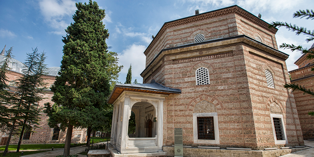
This property is a serial nomination of eight component sites in the City of Bursa and the nearby village of Cumalıkızık, in the southern Marmara region. The site illustrates the creation of an urban and rural system establishing the Ottoman Empire in the early 14th century. The property embodies the key functions of the social and economic organization of the new capital which evolved around a civic centre. These include commercial districts of khans, kulliyes (religious institutions) integrating mosques, religious schools, public baths and a kitchen for the poor, as well as the tomb of Orhan Ghazi, founder of the Ottoman dynasty. One component outside the historic centre of Bursa is the village of Cumalıkızık, the only rural village of this system to show the provision of hinterland support for the capital.
Outstanding Universal Value
Brief synthesis
Located on the slopes of Uludağ Mountain in the north-western part of Turkey, Bursa and Cumalıkızık represent the creation of an urban and rural system establishing the first capital city of the Ottoman Empire and the Sultan’s seat in the early 14th century. In the empire’s establishment process, Bursa became the first city, which was shaped by kulliyes, in the context of waqf (public endowments) system determining the expansion of the city and its architectural and stylistic traditions.
The specific development of the city emerged from five focal points, mostly on hills, where the five sultans (Orhan Ghazi, Murad I, Yıldırım Bayezid, Çelebi Mehmed, Murad II) established public kulliyes consisting of mosques, madrasahs (school), hamams (public baths), imarets (public kitchens) and tombs . These kulliyes, featuring as centres with social, cultural, religious and educational functions, determined the boundaries of the city. Houses were constructed near the kulliyes, turning into neighborhoods surrounding the kulliyes within the course of time. Kulliyes were also related with rural areas due to the waqf system. For example, the aim of Cumalıkızık as a waqf village, meaning that it permanently belonged to an institution (a kulliye), was to provide income for Orhan Ghazi Kulliye, as stated in historical documents.
The exceptional city planning methodology is expressed in the relationship of the five sultan kulliyes, one of which constitutes the core of the city’s commercial centre, and Cumalıkızık which is the best preserved waqf village in Bursa. This methodology developed during the foundation of the first Ottoman capital in early 14th century and expanded until the middle of the 15th century.
Criterion (i): Bursa was created and managed by the first Ottoman sultans, through an innovative and ingenious system, which developed an unprecedented urban planning process. Using the semi-religious Ahi brotherhood organizations to run commercial life, and making the best use of the public endowment system Waqf (relating kulliyes and villages), they established kulliyes as nuclei providing all public infrastructure services prior to the creation of neighbourhoods. These centres allowed for the fast establishment of a vivid, sustainable new capital for one of the most rapidly expanding empires of the world.
Criterion (ii): Bursa, as the first capital of the Ottoman Empire, was of key importance as a reference for the development of later Ottoman cities. The new urban development approach introduced by the early Ottoman Sultans was based on the construction of public infrastructure complexes outside the existing city core surrounded by walls, and created a new town for non-urban population, which became the model Ottoman city, later referenced throughout the expansion of the Ottoman Empire. The new capital, with its social, religious and commercial functions reflects the values of the society and the values it accepted from its neighbours, during long years of migration from central Asia to the West. This is also reflected in the integration of Byzantine, Seljuk, Arab, Persian and other influences in architectural stylistics.
Criterion (iv): Bursa and Cumalıkızık illustrate the first capital of the Ottoman Sultans, rulers of an Empire reaching from Anatolia to Yemen and including parts of Europe and North Africa for hundreds of years, which developed a unique architectural plan called “Bursa style” or “inverted T plan”. In the first stage, the inverted T planned mosques, with guest rooms, were able to meet the functions of independent buildings such as public kitchen and madrasah, which were constructed in the complexes as separate buildings, in later stages.
Kulliyes, as social units, meeting the requirements of the society and facilitating life, shaped the city by taking the multifunctional structure of this plan type as an example. In other words, the multifunctional inverted T plan is an exceptional building type which illustrates uniquely the city planning system in Bursa. These kulliyes, with their individual buildings constitute the urban nuclei of this system and characteristically shape the urban landscape of Bursa. While individual architectural components in Bursa can be considered as outstanding examples of architectural type, this criterion is met through the ensembles, created by these components (khans, bedesten, mosques, madrasahs, tombs, hamams, and houses).
Criterion (vi): Bursa is directly associated with important historical events, myths, ideas and traditions from the early Ottoman period. The mystic image of the city, created through the presence of the tombs of early Ottoman sultans and the famous Hacivat and Karagöz characters who were workers in the construction of the Orhan Ghazi Kulliye, retains close associations to early Ottoman life. Many sultans and courtiers, then the leaders of the Muslim World, recognized the importance of Bursa as the spiritual capital of the Ottoman Empire, even after the conquest of İstanbul and demonstrated their loyalty to their ancestors and the city, by choosing Bursa as the location for burial.
Integrity
The serial components were selected to represent all elements of the city and a village, as a planning and development system. The component parts were selected from the key structures which created the urban system, allowing for the expansion of a newly built and established capital city, in a short span of time. The only missing elements of the whole original system are some of the villages, which were originally part of the system and of which Cumalıkızık is the best preserved example.
While the urban planning system is represented through the kulliyes as well as the commercial quarter which developed around one of the kulliyes, the residential neighbourhoods surrounding the kulliyes contributed to the process of urban expansion. Their protection within the overall management is essential to the urban integrity both in visual and spatial terms. It seems possible, that additional components, such as road systems, gates or residential neighbourhoods may contribute to the representation of a full process of urban expansion in the future.
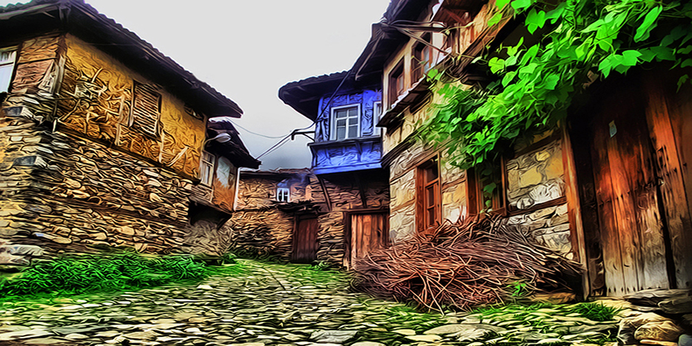
In terms of intactness, the kulliyes have partially suffered destructions during the 1855 earthquake and have undergone subsequent repairs. Some of the public kitchens integrated in the kulliyes have been lost over time. However, the kulliyes continue to function as the focal points and public spaces of various residential neighbourhoods at present. Buildings in the Khans Area, which developed around Emir Khan around the Orhan Ghazi Kulliye in the historical commercial axis, still preserve their original commercial functions at present, however, Pirinç Han and Kapan Han were partially harmed due to the construction of new streets during construction activities in the 19th century. Furthermore, Cumalıkızık Village, with unique examples of civil architecture has sustained its rural character. The setting of this village contributes to the understanding of the village function and agricultural production contributing to the sustenance of the kulliye.
Authenticity
Bursa and Cumalıkızık, as developed as an integrated whole by the first five Ottoman Sultans, illustrate the birth of the Ottoman Empire in the 14th and early 15th centuries. While preserving an adequate amount of the original 14th and 15th century fabric, some of the kulliyes in the serial components involve 19th century additions and partial reconstructions. Other structures such as some of the commercial units experienced destruction and reconstruction following fire. Yet, the Khans Area continues the tradesmen culture of the Ottoman era to date, including traditional rituals such as first sale of the day, bargaining, master-apprentice relations, and neighbourliness among tradesmen. The Khan’s courtyard plans have retained authenticity in form and design and have been effective for khans to sustain their commercial functions until the present.
In the kulliyes changes in use and function have occurred but are well documented. In Muradiye complex, for example, the public kitchen is used as a restaurant, and the hamam as a centre for physically-challenged people. In the Yesil complex the madrasah is now the Museum of Turkish Islamic Art. The kulliyes remain still focal points meeting the social, cultural and religious needs of the inhabitants, in accordance with their original public functions, and continue to reflect the Ottoman characteristics of Bursa.
The village of Cumalıkızık in its agricultural landscape provides an overall perception of a high degree of authenticity. Few of the houses are used for other than residential purposes and the village seems to have retained a special atmosphere, providing an impression of earlier times. Several aspects, like the village pattern, the form and layout schemes applied in the houses, the materials used, in particular the local stone for the ground floor, wood for the upper floors and the typology of roofs, the agricultural fields and the general setting give an original impression despite some 19th century reconstructions and regular repairs which have been undertaken at other times. It is important for the preservation of the integrity of Cumalıkızık to ensure the continuous presence of the local inhabitants and avoid processes of intense commercialization.
SOURCE: UNESCO.ORG